Warmest West Coast Waters In Decades – Maybe EVER

Warmest West Coast waters in decades – Maybe EVER (Ice Age Now, Nov 9, 2014):

What does it mean for winter?


Nothing short of historic

“Waters along the west coast of North America, from Baja California in Mexico to the Gulf of Alaska, are warmer than they’ve been in decades,”  says this article in the Washington Post. “The plume of warm water bleeding up the coast is nothing short of historic.”


Sea surface temperature difference from normal, November 3 (NOAA)


In_the_red-3Nov14


Maybe the warmest EVER

Writes the Seattle Times:

“The North Pacific hasn’t been this warm ever, as far as anyone knows. It’s really strange,” said Bill Peterson, oceanographer with NOAA’s Northwest Fisheries Science Center in Newport, Ore. “It looks like an El Niño, but it really isn’t. We don’t really know what it is.”

(I’m guessing that it’s caused by underwater volcanic activity. I wish we could follow that heat back to its source so that we would know.

“Marine biologists are stunned by an onslaught of outsider warm-water species up and down the West Coast,” the article continues.

“A likely contributor to the warmth is the high pressure (or ridging) pattern over the western U.S. this year. In this pattern, winds from the south push warm water eastward, allowing it to converge along the coast. More commonly, winds from the north hold warm waters in the tropics and produce upwelling which brings cold deep water towards the surface.

What does this mean for winter?

“They may portend more drought for the West Coast this winter, and cold, stormy conditions in the East,” the article concludes.

The warmer waters may also bring some drought relief in Southern California by enhancing the tropical moisture feed from the Pacific into the southern U.S.

See entire article:
http://www.washingtonpost.com/blogs/capital-weather-gang/wp/2014/11/04/in-the-red-west-coast-waters-are-warmest-in-decades-what-does-it-mean/

NOAA Polar Plunge – So Cold Its Purple

NOAA polar plunge – So cold its purple (Ice Age Now, Nov 7, 2014):

NOAA 6 – 10 Day Forecast  (issued Nov 6th)
Nov 12-16, 2014


So-Cold-its-Purple
Larger: http://www.cpc.ncep.noaa.gov/products/predictions/610day/610temp.new.gif
Root address: http://www.cpc.ncep.noaa.gov/products/predictions/610day/


NOAA 8 – 14 Day Forecast  (issued Nov 6th)
Nov. 14 – 20, 2014

Read moreNOAA Polar Plunge – So Cold Its Purple

TV: “This is really kind of scary… a grim reality” for West Coast — Alarm as baby whales keep dying; Since 2011 none have survived over a year — Biologist: We see them pregnant for weeks, then no longer pregnant — NOAA: “Not what we’re used to… Incredibly poor condition… Skeleton with skin” (VIDEO)

TV: “This is really kind of scary… a grim reality” for West Coast — Alarm as baby whales keep dying; Since 2011 none have survived over a year — Biologist: We see them pregnant for weeks, then no longer pregnant — NOAA: “Not what we’re used to… Incredibly poor condition… Skeleton with skin” (VIDEO) (ENENews, Nov 5, 2014):

King 5 News (Seattle), Oct. 21, 2014: Baby orca death triggers alarm; The recent loss… is sounding off alarms since its been years since a baby orca has survived — “Researchers say there is no hope for a missing baby orca… The baby — which was born just last month — is nowhere in sight… The loss of yet another baby orca… A grim reality is taking shape… This is really kind of scary, because it’s been years since one of these little guys has survived… Babies are not surviving, and [biologist Ken Balcomb] says some whales appear pregnant for weeks, only to be seen later no longer pregnant… Some scientists believe the orcas… could be poisoning their own babies with toxic mother’s milk.”

Read moreTV: “This is really kind of scary… a grim reality” for West Coast — Alarm as baby whales keep dying; Since 2011 none have survived over a year — Biologist: We see them pregnant for weeks, then no longer pregnant — NOAA: “Not what we’re used to… Incredibly poor condition… Skeleton with skin” (VIDEO)

60% Of California Will Remain In Drought Through Winter, NOAA Warns

60% Of California Will Remain In Drought Through Winter, NOAA Warns (ZeroHedge, Oct 17, 2014):

Just wehn you thought it was safe to shower again, NOAA issues their US seasonal drought outlook and crushes dreams of wetter winter helping Californians. Hopes for heavy rain from El Nino will not be enough to change the drought situation for 60% of Californians, as MotherJones reports, NOAA forecasters warn, “While we’re predicting at least a 2 in 3 chance that winter precipitation will be near or above normal throughout the state, with such widespread, extreme deficits, recovery will be slow.”

NOAA – 1695 Low Max Records Broken or Tied From Sept 11 to Sept 20. One record broken by 25F

NOAA – 1695 Low Max Records Broken or Tied From Sept 11 to Sept 20. One record broken by 25F  (Sunshine Hours, Sep 27, 2014):

Wow. One record was broken by 25F!!!!

1695 Low Max Records Broken or  Tied From Sept 11 to Sept 20 according to the NOAA.

A “Low Max” means that the maximum temperatures for the day was the lowest it has ever been. This indicates daytime cooling.

Below is a screenshot showing location and the biggest difference between old record and new record.

Read moreNOAA – 1695 Low Max Records Broken or Tied From Sept 11 to Sept 20. One record broken by 25F

NOAA – 28,504 Cold Records Set During Last Year

NOAA – 28,504 Cold Records Set During Last Year (Sunshine Hours, July 24 2014):

28,504 Low Max Records were set in last 365 days according to the NOAA.

A “Low Max” means that the maximum temperatures for the day was the lowest it has ever been.

This indicates daytime cooling.

Only 13205 High Max records were set. That is  over a 2:1 ratio. Brrr.

lowmax_2014_july_24

Shocking Climate Change Update

GOT FOOD?


polar-bear

“Megablizzard” forecast for eastern Australia (Ice Age Now, June 23, 2014):

“Best snowfalls in a decade.” Maybe the “storm of the century.”

Aleutian volcanoes waking up (Ice Age Now, June 23, 2014):

Five volcanoes now simultaneously active, the most activity in 26 years.

Record snowfall in Norway (Ice Age Now, June 23, 2014):

First time since records began that snow has been recorded in June.

Surprise Snowstorm Clobbers Rockies (Ice Age Now, June 23, 2014):

June 20, 2014 – “A bizarre June snowstorm hit Glacier National Park in Montana and parts of Utah and Idaho this week,

Confirmed – Earth’s protective magnetic shield is weakening (Ice Age Now, June 22, 2014):

The most dramatic declines are occurring over the Western Hemisphere, says European Space Agency.

Read moreShocking Climate Change Update

Professor: Concerns Fukushima is impacting Alaska; “Unusual animals showing up dead… Seals with unknown disease… first cases of avian cholera” – NOAA: ‘Rare whale beachings’ in Alaska under investigation – Japan Paper: Mysterious sea creatures found one after another along coast (PHOTOS)

Japan-sea-creatures

Professor: Concerns Fukushima is impacting Alaska; “Unusual animals showing up dead… Seals with unknown disease… first cases of avian cholera” — NOAA: ‘Rare whale beachings’ in Alaska under investigation — Japan Paper: Mysterious sea creatures found one after another along coast (PHOTOS) (ENENews, May 10, 2014):

Nome Nugget, Mar. 27, 2014: Radiation sampling to happen for Bering Strait — Regional concerns about the possibility that Bering Sea waters could be radioactively contaminated […] “People throughout our region have repeatedly asked for testing of our subsistence foods and water,” said [University of Alaska, Fairbanks professor Gay Sheffield]. “Seals fell sick with a still unknown disease, we’ve had the documented first cases of avian cholera in Alaska, we’ve had unusual animals like the beaked whale showing up dead on the beach near Gambell and each time people throughout the region expressed concerns about the effects of Fukushima either in the air, and now with the approaching plume in the water,” said Sheffield. […] Gambell Tribal President Eddie Ungott agreed and said that his village is very concerned about radiation. […] IRA President Paul Rookok, Sr. said they are worried about the health of marine mammals […]

Read moreProfessor: Concerns Fukushima is impacting Alaska; “Unusual animals showing up dead… Seals with unknown disease… first cases of avian cholera” – NOAA: ‘Rare whale beachings’ in Alaska under investigation – Japan Paper: Mysterious sea creatures found one after another along coast (PHOTOS)

September 21 Breaks The Record For Most Sea Ice Ever Measured At Either Pole

September 21 Breaks The Record For Most Sea Ice Ever Measured At Either Pole (Real Science, Sep 23, 2013):

On September 21, Antarctica had the most sea ice ever measured at either pole – 19,514,000 km².  The extent of southern hemisphere sea ice has increased dramatically since the start of satellite records in 1979.

Index of /DATASETS/NOAA/G02135/south/daily/data/

Most people with an IQ over 30 understand that ice forms when the air is cold, but this seems to exclude a significant number of government scientists.

Hundreds Of Starving, Dying Sea Lions Washing Up On Beaches From San Diego To Santa Barbara

Fukushima, anyone?


Starving, Dying Sea Lions Washing Up On Southland Beaches (CBS News):


Starving sea lion pups fill Calif. rescue centers (AP, March 29, 2013):

LOS ANGELES (AP) — Hundreds of starving sea lion pups are washing up on beaches from San Diego to Santa Barbara, overwhelming rescue centers and leaving scientists scrambling to figure out why.

At island rookeries off the Southern California coast, 45 percent of the pups born in June have died, said Sharon Melin, a wildlife biologist for the National Marine Fisheries Service based in Seattle. Normally, less than one-third of the pups would die.

It’s gotten so bad in the past two weeks that the National Oceanic and Atmospheric Administration declared an “unusual mortality event.” That will allow more scientists to join the search for the cause, Melin said.

Pups are normally weaned from their mothers in April.

Even the pups that are making it are markedly underweight, Melin said.

The most recent pups weighed at the breeding area on San Miguel Island were around 37 pounds, Melin said. They should weigh between 55 and 59 pounds by now, she said.

Read moreHundreds Of Starving, Dying Sea Lions Washing Up On Beaches From San Diego To Santa Barbara

NOAA: Japanese Tsunami Debris ‘To Reach Hawaii In Next Few Days’

Japanese tsunami debris ‘to reach Hawaii in next few days’ (Telegraph, Feb. 29, 2012):

The National Oceanic and Atmospheric Administration estimated the first bits of tsunami debris will make landfall soon on small atolls northwest of the main Hawaiian Islands. The rest of the debris was expected to reach the coasts of Oregon, Washington state, Alaska and Canada around 2014.

NOAA’s tsunami marine debris coordinator, Ruth Yender, told an online news conference Tuesday that agency workers were boarding Coast Guard flights that patrol the archipelago. NOAA also asked scientists stationed at Midway and other atolls to look for the debris.

Read moreNOAA: Japanese Tsunami Debris ‘To Reach Hawaii In Next Few Days’

Expect A Cold Winter: NOAA Sea Surface Temperatures Map

Click on image to enlarge.

Source: NOAA

Look at those places where the sea surface temperatures are below normal …

See also:

Britain Faces Mini Ice Age That Could Last For Decades

Vancouver, Western Canada Facing Record Cold Temperatures This Winter

… and expect a cold winter in the Pacific Northwest and in the UK.

US Government Scientists Tell Power Companies To Prepare For Possible Disruptions As Solar Storms Set To Hit Earth

See also:

NOAA: Solar Storms Could Debilitate Earth this Decade


Power companies prepare as solar storms set to hit Earth (Reuters. Aug 6, 2011):

Three large explosions from the Sun over the past few days have prompted U.S. government scientists to caution users of satellite, telecommunications and electric equipment to prepare for possible disruptions over the next few days.

“The magnetic storm that is soon to develop probably will be in the moderate to strong level,” said Joseph Kunches, a space weather scientist at the Space Weather Prediction Center, a division of the U.S. National Oceanic and Atmospheric Administration (NOAA).

He said solar storms this week could affect communications and global positioning system (GPS) satellites and might even produce an aurora visible as far south as Minnesota and Wisconsin.

An aurora, called aurora borealis or the northern lights in northern latitudes, is a natural light display in the sky in the Arctic and Antarctic regions caused by the collision of energetic charged particles with atoms in the high altitude atmosphere.

Read moreUS Government Scientists Tell Power Companies To Prepare For Possible Disruptions As Solar Storms Set To Hit Earth

NOAA: Solar Storms Could Debilitate Earth this Decade

Solar Storms Could Debilitate Earth this Decade: NOAA (International Business Times, August 6, 2011):

The National Oceanic and Atmospheric Administration, a federal agency that focuses on the condition of the oceans and atmosphere, said that a severe solar storm could cause global chaos, debilitating satellite communications and taking down the most important global power grids.

The NOAA predicted four extreme solar emissions which could threaten the planet this decade. Similarly, NASA warned that a peak in the sun’s magnetic energy cycle and the number of sun spots or flares around 2013 could enable extremely high radiation levels.

Government studies revealed that extreme solar flare emissions could cause blackouts, possibly for years, in large portions of the U.S.

This type of storm could also induce geomagnetic currents that could debilitate transformers on the power grid. Electric power would be out for years or even decades.

Read moreNOAA: Solar Storms Could Debilitate Earth this Decade

NOAA Satellite Map Shows Most of Northern Hemisphere is Covered in Snow and Ice

No matter what happens the warmist fraudsters will always claim that everything is happening because of man-made global warming.

Even this? 70 Trillion Cubic Feet of NEW ARTIC ICE

There is no global warming and there certainly never was a man-made global warming and CO2 has nothing do to with a warming climate, because rising CO2 levels always lag 800 years behind rising temperatures.

You can even see that relation also in Al GWhore’s fake hockey stick graph.

Science has become totally unscientific:

On The Current State Of Climate Science: Unequivocal Equivocation – An Open Letter To Dr. Trenberth

These are YOUR man-made global warming experts:

Top Expert Dr. David Viner (University of East Anglia) in 2000: ‘Children just aren’t going to know what snow is’

The elitists seem to know exactly what is really going on:

Global Cooling and the New World Order (Telegraph):

“The 58th Bilderberg Meeting will be held in Sitges, Spain 3 – 6 June 2010. The Conference will deal mainly with Financial Reform, Security, Cyber Technology, Energy, Pakistan, Afghanistan, World Food Problem, Global Cooling, Social Networking, Medical Science, EU-US relations.”

Yep, that’s right. Global Cooling.

The elitists may have just intentionally caused a mini Ice Age:

Life on this Earth Just Changed: The North Atlantic Current is Gone

30 Facts – The Rothschild Bankers Planned The Gulf Disaster

Jesse Ventura Conspiracy Theory: ‘Gulf Coast Oil Spill’

The bottom line is always money, power and control and not the truth.


(Click on images to enlarge.)

A new satellite map by the government agency NOAA shows the extent of the snow blanketing a vast area from the west coast of Canada to eastern China


At first glance it looks like a graphic from a Discovery Channel programme about a distant ice age. But this astonishing picture shows the world as it is today – with half the Northern Hemisphere covered with snow and ice.

The image was released by the National Oceanic And Atmospheric Association (NOAA) on the day half of North America was in the grip of a severe winter storm.

The map was created using multiple satellites from government agencies and the US Air Force.

That Antarctica, the Arctic, Greenland and the frozen wastes of Siberia are covered in white comes as no surprise. But it is the extent to which the line dips down over the Northern Hemisphere that is so remarkable about the image.

The shroud of white stretches down from Alaska and sweeps through the Midwest and along to the Eastern seaboard. The bitter cold has reached as far as Texas and northern Mexico where in Ciudad Juarez temperatures today were expected to dip to minus 15C.

In the U.S. tens of millions of people chose to stay at home rather than venture out. In Chicago, 20in of snow fell leading to authorities closing schools for the first time in 12 years. The newspaper for Tulsa, Okalahoma, was unable to publish its print edition for the first time in more than a century.

This particular storm is the result from two clashing air masses which, if not unprecedented, is extraordinarily rare for its size and ferocious strength.

‘A storm that produces a swath of 20in snow is really something we’d see once every 50 years – maybe,’ said a U.S. National Weather Service meteorologist.


Hundreds of drivers on Lake Shore Drive in Chicago, which was blasted by 20 inches of snow, abandoned their cars in an almost apocalyptic scene as authorities closed the road

Louis Uccellini, director of the government’s National Centers for Environmental Prediction, said the U.S. storm also drew strength from the La Nina condition currently affecting the tropical Pacific Ocean.

La Nina is a periodic cooling of the surface temperatures of the tropical Pacific Ocean, the opposite of the better-known El Nino warming. Both can have significant impacts on weather around the world by changing the movement of winds and high and low pressure systems.


A scene from sci-fi film The Day After Tomorrow? No, these are cars stuck in the northbound lanes of Lake Shore Drive, Chicago, after accidents and drifting snow stranded the drivers during last night’s blizzard. As of late morning more than 20in of snow had fallen, making this snowstorm the third largest recorded in the city

The NOAA image shows how the weather is affecting Scotland and begins in earnest from southern Germany, through Italy and down into Greece, Turkey and Iran. Northern areas of India and China are also affected.

The startling image was released on the same day Al Gore stepped up to defend his claim that global warming causes the bitterly cold weather. Thirty states in America are affected by a two-day blizzard.

Writing in his blog Al’s Journal, he said: ‘As it turns out, the scientific community has been addressing this particular question for some time now and they say that increased heavy snowfalls are completely consistent with what they have been predicting as a consequence of man-made global warming.’

Hilarious! This is what thosefraudsters call ‘completely consistent’:

Top Expert Dr. David Viner (University of East Anglia) in 2000: ‘Children just aren’t going to know what snow is’

His response came after Fox News pundit Bill O’Reilly challenged the former Vice President to give his thoughts on ‘why southern New York has turned into the tundra’.

Read moreNOAA Satellite Map Shows Most of Northern Hemisphere is Covered in Snow and Ice

Louisiana Senator Blasts President Obama About COREXIT Poisoning of the Gulf

See also:

30 Facts – The Rothschild Bankers Planned The Gulf Disaster

Jesse Ventura Conspiracy Theory: ‘Gulf Coast Oil Spill’ (Must-see!)

More shocking information at the end of Senator Crow’s letter.


1/16/2011

The Honorable Barack Obama
The President of the United States
1600 Pennsylvania Avenue
Washington, D.C. 20500

Re: The environmental impact of dispersing Corexit during and after the oil spill

Dear Mr. President;

The BP incident in the Gulf of Mexico has now been acknowledged as the greatest manmade disaster in history but there is yet another manmade disaster that must not be overlooked and has not been adequately addressed in the recently released report of the National Commission on the BP Deepwater Horizon oil disaster.

That second major disaster has been caused by the unnecessary use of the toxin Corexit dispersant. In early May of 2010 just after the crisis began, I requested that our Louisiana Attorney General Buddy Caldwell use whatever legal means were necessary to stop the use of this toxin. Shortly thereafter, Louisiana Governor Bobby Jindal requested that the use of this toxic dispersant be discontinued because of the long-term environmental damage. And still later, it was reported in the media that you also ordered BP to stop using Corexit. Surprisingly, I also read in the media that they even refused your request.

Mr. President, my concern is that this toxic and damaging chemical is still being used and it will compound the long-term damage to our state, our citizens, our eco-system, our economy, our seafood industry, our wildlife and our culture.

I am well aware that our emphasis, resources and energy is currently engaged working through the administrative and legal proceedings of the oil disaster but we must also recognize and begin the same process to address the damage Corexit has done and will continue to do as we go forward.

As the State Senator for District 1 in the southeastern corner of the State of Louisiana representing the parishes of St. Tammany, St. Bernard, Orleans and Plaquemines, I respectfully request that you have your administrative officials provide the information requested in this letter. I need to make that information available to my constituents who are seeing their lives and lands threatened and their way of life hanging in the balance. Due to the threats to public safety and ecological realities, I am compelled to write this letter requesting answers to my questions regarding the role of the United States Government in administering the response to the crises in the Gulf. It is apparent that the response directed by our government was inadequate because it allowed the use of Corexit dispersants which increased the toxicity level of the spilled oil and delivered no substantial benefit.

Corexit dispersants increased the toxicity of the oil itself when the two were mixed together. Its use caused the cross contamination of the Gulf water column by forcing the transfer of the surface oil downward through the water column, causing the oil to sink to the Gulf floor. The result was an unnecessary elevated negative impact as this same oil moved ashore later to the tidal zones delivering toxic weathered oil to coastal residents, tourists and businesses and workers in the Gulf region.

Government officials stated over and over that the use of the dispersants was designed to break up the oil into smaller digestible parts to be consumed by the sub-sea living micro-organisms. This strategy is unsubstantiated. In fact, the Corexit dispersant created the opposite results since Corexit contains toxic ingredients which act as biocides to prevent microbial digestion of the oil. Physical evidence supports that the entire response administered by government agencies have been inadequate.

Read moreLouisiana Senator Blasts President Obama About COREXIT Poisoning of the Gulf

The Spill, The Scandal and the President: The inside story of how Obama failed to crack down on the corruption of the Bush years – and let the world’s most dangerous oil company get away with murder

“BP Atlantis”!


the-spill-the-scandal-and-president-obama
President Obama in Port Fourchon, Louisiana, May 28, 2010.

This article originally appeared in RS 1107 from June 24, 2010.

(Rolling Stone Magazine) — On May 27th, more than a month into the worst environmental disaster in U.S. history, Barack Obama strode to the podium in the East Room of the White House. For weeks, the administration had been insisting that BP alone was to blame for the catastrophic oil spill in the Gulf – and the ongoing failure to stop the massive leak. “They have the technical expertise to plug the hole,” White House spokesman Robert Gibbs had said only six days earlier. “It is their responsibility.” The president, Gibbs added, lacked the authority to play anything more than a supervisory role – a curious line of argument from an administration that has reserved the right to assassinate American citizens abroad and has nationalized much of the auto industry. “If BP is not accomplishing the task, can you just federalize it?” a reporter asked. “No,” Gibbs replied.

Now, however, the president was suddenly standing up to take command of the cleanup effort. “In case you were wondering who’s responsible,” Obama told the nation, “I take responsibility.” Sounding chastened, he acknowledged that his administration had failed to adequately reform the Minerals Management Service, the scandal-ridden federal agency that for years had essentially allowed the oil industry to self-regulate. “There wasn’t sufficient urgency,” the president said. “Absolutely I take responsibility for that.” He also admitted that he had been too credulous of the oil giants: “I was wrong in my belief that the oil companies had their act together when it came to worst-case scenarios.” He unveiled a presidential commission to investigate the disaster, discussed the resignation of the head of MMS, and extended a moratorium on new deepwater drilling. “The buck,” he reiterated the next day on the sullied Louisiana coastline, “stops with me.”

What didn’t stop was the gusher. Hours before the president’s press conference, an ominous plume of oil six miles wide and 22 miles long was discovered snaking its way toward Mobile Bay from BP’s wellhead next to the wreckage of its Deepwater Horizon rig. Admiral Thad Allen, the U.S. commander overseeing the cleanup, framed the spill explicitly as an invasion: “The enemy is coming ashore,” he said. Louisiana beaches were assaulted by blobs of oil that began to seep beneath the sand; acres of marshland at the “Bird’s Foot,” where the Mississippi meets the Gulf, were befouled by shit-brown crude – a death sentence for wetlands that serve as the cradle for much of the region’s vital marine life. By the time Obama spoke, it was increasingly evident that this was not merely an ecological disaster. It was the most devastating assault on American soil since 9/11.

Like the attacks by Al Qaeda, the disaster in the Gulf was preceded by ample warnings – yet the administration had ignored them. Instead of cracking down on MMS, as he had vowed to do even before taking office, Obama left in place many of the top officials who oversaw the agency’s culture of corruption. He permitted it to rubber-stamp dangerous drilling operations by BP – a firm with the worst safety record of any oil company – with virtually no environmental safeguards, using industry-friendly regulations drafted during the Bush years. He calibrated his response to the Gulf spill based on flawed and misleading estimates from BP – and then deployed his top aides to lowball the flow rate at a laughable 5,000 barrels a day, long after the best science made clear this catastrophe would eclipse the Exxon Valdez.

noaa_estimate_64000_to_-110000_barrels_-a_day
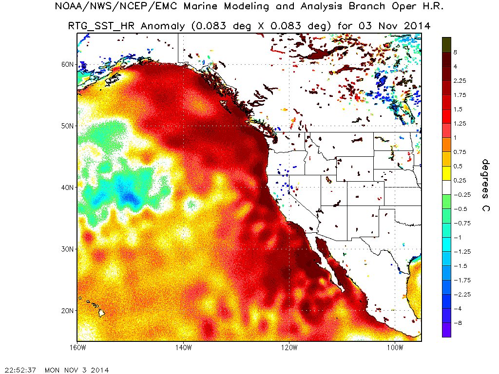
Hours after BP’s rig sank on April 22nd, a white board in NOAA’s “war room” in Seattle displays the administration’s initial, worst-case estimate of the spill — 64,000 to 110,000 barrels a day.

Even after the president’s press conference, Rolling Stone has learned, the administration knew the spill could be far worse than its “best estimate” acknowledged. That same day, the president’s Flow Rate Technical Group – a team of scientists charged with establishing the gusher’s output – announced a new estimate of 12,000 to 25,000 barrels, based on calculations from video of the plume. In fact, according to interviews with team members and scientists familiar with its work, that figure represents the plume group’s minimum estimate. The upper range was not included in their report because scientists analyzing the flow were unable to reach a consensus on how bad it could be. “The upper bound from the plume group, if it had come out, is very high,” says Timothy Crone, a marine geophysicist at Columbia University who has consulted with the government’s team. “That’s why they had resistance internally. We’re talking 100,000 barrels a day.”

The median figure for Crone’s independent calculations is 55,000 barrels a day – the equivalent of an Exxon Valdez every five days. “That’s what the plume team’s numbers show too,” Crone says. A source privy to internal discussions at one of the world’s top oil companies confirms that the industry privately agrees with such estimates. “The industry definitely believes the higher-end values,” the source says. “That’s accurate – if not more than that.” The reason, he adds, is that BP appears to have unleashed one of the 10 most productive wells in the Gulf. “BP screwed up a really big, big find,” the source says. “And if they can’t cap this, it’s not going to blow itself out anytime soon.”

Even worse, the “moratorium” on drilling announced by the president does little to prevent future disasters. The ban halts exploratory drilling at only 33 deepwater operations, shutting down less than one percent of the total wells in the Gulf. Interior Secretary Ken Salazar, the Cabinet-level official appointed by Obama to rein in the oil industry, boasts that “the moratorium is not a moratorium that will affect production” – which continues at 5,106 wells in the Gulf, including 591 in deep water.

Most troubling of all, the government has allowed BP to continue deep-sea production at its Atlantis rig – one of the world’s largest oil platforms. Capable of drawing 200,000 barrels a day from the seafloor, Atlantis is located only 150 miles off the coast of Louisiana, in waters nearly 2,000 feet deeper than BP drilled at Deepwater Horizon. According to congressional documents, the platform lacks required engineering certification for as much as 90 percent of its subsea components – a flaw that internal BP documents reveal could lead to “catastrophic” errors. In a May 19th letter to Salazar, 26 congressmen called for the rig to be shut down immediately. “We are very concerned,” they wrote, “that the tragedy at Deepwater Horizon could foreshadow an accident at BP Atlantis.”

The administration’s response to the looming threat? According to an e-mail to a congressional aide from a staff member at MMS, the agency has had “zero contact” with Atlantis about its safety risks since the Deepwater rig went down.

Read moreThe Spill, The Scandal and the President: The inside story of how Obama failed to crack down on the corruption of the Bush years – and let the world’s most dangerous oil company get away with murder

Matt Simmons on Bloomberg: There Is A Much Larger Leak, Creating A Gigantic Plume; US Military Should Take Over And Use Nuclear Weapons to Seal The Blowout


Added: 28. Mai 2010

May 28 (Bloomberg) — Matt Simmons, founder and chairman emeritus of Simmons & Co., talks with Bloomberg’s Mark Crumpton and Lori Rothman about BP Plc’s leaking oil well in the Gulf of Mexico.

BP said in a statement today that it has spent $930 million responding to the spill, which began after an April 20 rig explosion that killed 11 workers.

The well has been spewing an estimated 12,000 to 19,000 barrels of oil a day into the Gulf, a U.S. government panel said yesterday.

Read moreMatt Simmons on Bloomberg: There Is A Much Larger Leak, Creating A Gigantic Plume; US Military Should Take Over And Use Nuclear Weapons to Seal The Blowout

Are the oceans giving up?

Studies seem to indicate that oceans, which are major carbon sinks, may have had enough. If so, the consequences are BAD, writes Jayalakshmi K.

Ocean deserts, which are non-productive areas, have increased by 15 per cent in the period 1998-2007, according to a study done by the National Oceanic and Atmospheric Administration (NOAA) in the US and the University of Hawaii. This translates into a total of 6.6 million sq km. On the whole, there are 51 million sq km of such desert zones. The data was collected by Nasa’s orbiting SeaStar craft.

Attributed mostly to warming surface waters, which is happening at a rate of 1 per cent every year, this creates many layers in the ocean waters, preventing deep ocean nutrients from rising to the surface and feeding plant life.

Read moreAre the oceans giving up?

Chinook Salmon Vanish Without a Trace

SACRAMENTO – Where did they go?

The Chinook salmon that swim upstream to spawn in the fall, the most robust run in the Sacramento River, have disappeared. The almost complete collapse of the richest and most dependable source of Chinook salmon south of Alaska left gloomy fisheries experts struggling for reliable explanations – and coming up dry.

Whatever the cause, there was widespread agreement among those attending a five-day meeting of the Pacific Fisheries Management Council here last week that the regional $150 million fishery, which usually opens for the four-month season on May 1, is almost certain to remain closed this year from northern Oregon to the Mexican border. A final decision on salmon fishing in the area is expected next month.

As a result, Chinook, or king salmon, the most prized species of Pacific wild salmon, will be hard to come by until the Alaskan season opens in July. Even then, wild Chinook are likely to be very expensive in markets and restaurants nationwide.

Read moreChinook Salmon Vanish Without a Trace