
– Incredible early-season snow slams the Southeast, impacts felt across eastern U.S. (Washington Post, Nov 1, 2014):
3:00 p.m. update:NWS Morristown reports up to 22? of snow fell at Mt LeConte in Tennessee’s Smoky Mountains, with drifts waist deep there.
Here are several new share-worthy items from this stunning mid-fall snowstorm:
Wow! Beautiful! RT @overbay_ted: Contrasting styles. @WJHL11@BWalder_WJHL@weatherchannel #tnwx#nolichuckeyriver pic.twitter.com/YjjTe35I50
— NWSMorristown (@NWSMorristown) November 1, 2014
Snowed in! Gatlinburg, TN! @spannpic.twitter.com/GUwk4ZzEBz
— Hannah Crooks (@Hannah_Crooks) November 1, 2014
A stunning look at our Southeast snow-maker. Roughly 1000 mb and dropping. https://t.co/IxwJo0CzOspic.twitter.com/jkiVMyiGuK
— Tim Ballisty (@IrishEagle) November 1, 2014
Original story from 11:35 a.m…
Snow to start November in South Carolina? Basically unheard of. Until today.
The snow is not just the mountains either. An extremely unusual cold pocket of air has brought record early-season snow to low-elevation spots like Columbia, South Carolina. In the Smoky Mountains, and surrounding parts of the Appalachians, measurements well past one foot have been recorded.
This all comes on the heels of a big windstorm and massive waves in and around the Great Lakes on Halloween. The storm will also impact the Northeast on its way out to sea.
Perhaps the most incredible aspect of this amazing storm is the low elevation snow in the southeast. Columbia, South Carolina is a shining example.
@BobVanDillen In Columbia South Carolina right now pic.twitter.com/dtA933lfpJ
— jeff Rubin (@RubinJeff) November 1, 2014
Reports range from about 1? in the area to as much as 4? or so. Keep in mind, this area is around 200-300 feet elevation in South Carolina. At the start of November.
WOW..Randall Mungo reporting 4? in Lexington, SC #scwxpic.twitter.com/8eFsUqJZ2P
— Ed Piotrowski (@EdPiotrowski) November 1, 2014
According to the National Weather Service office there, this is the earliest measurable snow has been recorded in Columbia. In fact, there have only been two other Novembers since the 1800s with snow accumulation in that city.
Here’s a look at all the time measurable snow has falling in the month of November in Columbia, SC. pic.twitter.com/Y31vI1FoQa
— Brad Panovich (@wxbrad) November 1, 2014
Add in some elevation, and the snow totals go way up. The Smoky Mountains on the border of Tennessee and North Carolina have been particularly hard hit. Some of the highest mountain peaks are reported to have picked up between one and two FEET of snow. At least a little more is to come.
Wow! Amazing winter wonderland in Gatlinburg, TN! Getting reports of snow totals nearing 2 feet on Mt LeConte… pic.twitter.com/iqXRwOk9ko
— Richard Scott (@Richard_wvua) November 1, 2014
Our Smokies Fishing Snowman in Gatlinburg TN #snowpic.twitter.com/fTbQMvgdUj
— Jonny Handy (@jonnyhandy) November 1, 2014
Near Gatlinburg by Kimberly Jones @spann@simpsonwhntpic.twitter.com/Jf0ZNbAePJ
— Tony Bearden (@tbearden01) November 1, 2014
@wxbrad Good Morning from Beech Mountain! pic.twitter.com/riyby7NJkv
— Yoenis Cespedes (@AppFlyer) November 1, 2014
28°F in Beech Mountain and still snowing. Photo Credit: Katrina Hinson #NCwx#snow#Snovembrrrrpic.twitter.com/JgHTfFklMb
— Vicki Graf (@VickiGrafWSOC9) November 1, 2014
Further north, through the mountainous portions of Virginia and West Virginia, several inches of snow have fallen with more on the way.
Crazy amount of #snow in Coeburn, Virginia from viewer JoAnna Hobbs. @weatherchannel#VAwxpic.twitter.com/hUWy3WZfn0
— Justin Abraham (@jjabraham) November 1, 2014
@foxandfriends 3 inches of snow & still falling. #MeadowsOfDan Virginia #BlueRidge mountains. pic.twitter.com/ExE80GF9dQ
— Homunculus (@HomunculusLoikm) November 1, 2014
Wet and snowy AM in WV. First #Snow RT 20 near Princeton, WV Mercer Co. Thanks Scotty Hagerman for sharing. #NovOnepic.twitter.com/BzNDovYw1l
— KEVIN JACOBS (@KELVINCELSIUSWX) November 1, 2014
@NWSBlacksburg@JimCantore@capitalweather@SwVirginiaWx 3? snow here in Woodlawn, VA this morning. Still snowing pic.twitter.com/pBogf6JSvg
— Clark Fincher (@clarkdocvet) November 1, 2014
Today’s snow wasn’t the first major impact from this big early-season winter storm. Yesterday, wicked winds and record Halloween snow rocked Chicago as well as other areas across the Great Lakes region.
Dubbed the Halloween Howler by local media, wave heights past 20 feet were seen in and around Chicago as wind gusts as high as 60-70 mph blasted the region on Friday.
21 ft waves, gusts of 50: I thought, I must get back to Chicago! Here I come! Photo credit: @erikapallasmoore pic.twitter.com/i7tyW183Kr
— Ginger Zee (@Ginger_Zee) November 1, 2014
Chicago’s lakefront, rush hour, Halloween. Whoa. Tribune photo by E. Jason Wambsgans @ejwamb#chicagoweather#wavespic.twitter.com/xqrUFVChH4
— Chi Trib Photo (@ChiTribPhoto) November 1, 2014
The Chicago Weather Center has more great pictures as well, and NWS Chicago has a recap on the high wind and wave event.
Now what?
This morning’s radar showed the extreme cold pocket over the Southeast U.S. The upper-level low pressure responsible for dumping snow on that region will move offshore and to the northeast through early Monday.
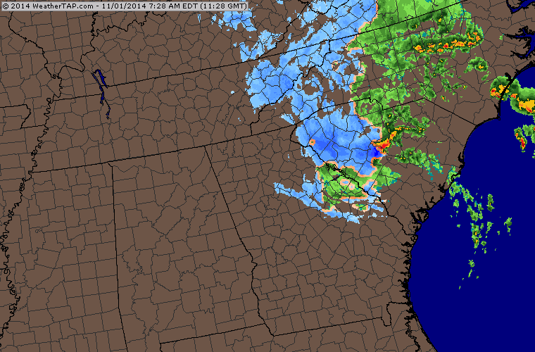
Saturday morning radar shows the upper level swirl impacting the southeast. (Weathertap)
On its trip out to sea, a strong coastal storm will continue to develop. By tomorrow afternoon, it is expected to be east of New England, bringing heavy rain and snow to parts of that region. Maine and adjacent locations in Canada are likely to get hit particularly hard with blinding snow and angry winds.
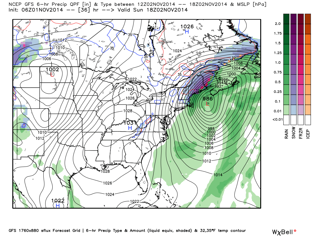
GFS model forecast for Sunday afternoon showing a large storm off New England. (Weatherbell.com)
Winds in the wake of the storm will continue to rip across much of the East Coast throughout the weekend, causing at least isolated power outages. Outages may be widespread in areas that received the heaviest of snow.
If all that wasn’t enough, a large portion of the eastern United States is facing a cold night tonight as well as the next several. A huge area of the mid-South is at risk for a freeze tonight, and that will progress eastward tomorrow night.
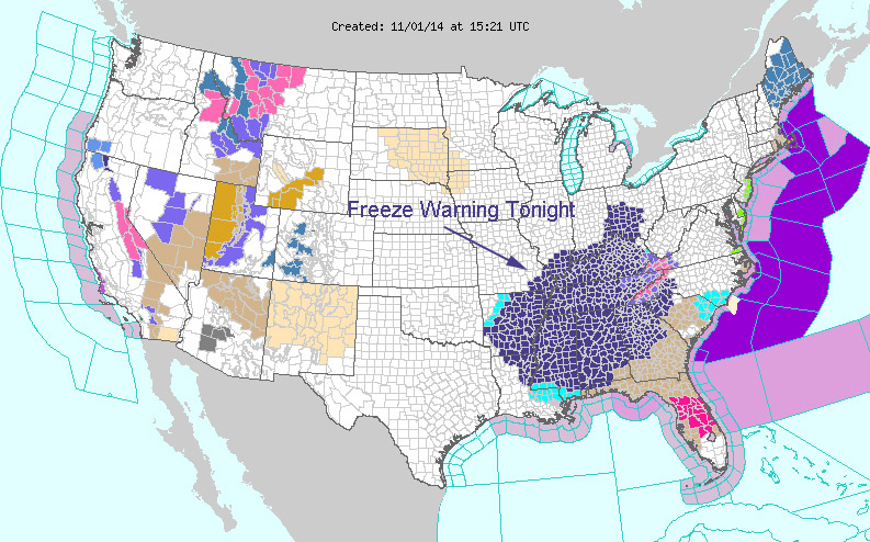
U.S. weather warnings, showing a large area at risk for a freeze tonight. (NOAA, modified by CWG)
Welcome to winter 2014-15!
(Screenshot – Click on image to enlarge.)
– Snowfalls are now just a thing of the past (The Independent, March 20, 2000):
Britain’s winter ends tomorrow with further indications of a striking environmental change: snow is starting to disappear from our lives.
Sledges, snowmen, snowballs and the excitement of waking to find that the stuff has settled outside are all a rapidly diminishing part of Britain’s culture, as warmer winters – which scientists are attributing to global climate change – produce not only fewer white Christmases, but fewer white Januaries and Februaries.
The first two months of 2000 were virtually free of significant snowfall in much of lowland Britain, and December brought only moderate snowfall in the South-east. It is the continuation of a trend that has been increasingly visible in the past 15 years: in the south of England, for instance, from 1970 to 1995 snow and sleet fell for an average of 3.7 days, while from 1988 to 1995 the average was 0.7 days. London’s last substantial snowfall was in February 1991.
Global warming, the heating of the atmosphere by increased amounts of industrial gases, is now accepted as a reality by the international community. Average temperatures in Britain were nearly 0.6°C higher in the Nineties than in 1960-90, and it is estimated that they will increase by 0.2C every decade over the coming century. Eight of the 10 hottest years on record occurred in the Nineties.
However, the warming is so far manifesting itself more in winters which are less cold than in much hotter summers. According to Dr David Viner, a senior research scientist at the climatic research unit (CRU) of the University of East Anglia,within a few years winter snowfall will become “a very rare and exciting event”.
“Children just aren’t going to know what snow is,” he said.
…